Arrival City
Temuco Chile (ZCO)
Departure City
Punta Arenas (PUQ)
Guided or
Self-Guided Tour
Best Season
November to March
Ride across the wildest edges of South America, from smoking volcanoes to icy fjords, on the ultimate Patagonian motorcycle journey.
This self-guided adventure starts in the adventure hub of Pucón in Chile, nestled at the foot of the active Villarrica Volcano. From there, you head south, crossing into Argentina’s iconic Bariloche region, along Argentina’s spectacular Route of the Seven Lakes, passing crystal-clear waters and snow-capped peaks.
Carving your way back into Chile via the remote border at Futaleufú, the route leads you deep into the heart of Patagonia along the legendary Carretera Austral. Here, the landscapes turn wild and raw: lush temperate rainforests, hanging glaciers, turquoise rivers, and endless gravel curves.
You’ll ride through charming towns like Coyhaique and Puerto Río Tranquilo, where optional detours include boating to the surreal Marble Caves or exploring the remote Laguna San Rafael. After crossing back into Argentina at Chile Chico, the terrain becomes drier and starker – the vast Patagonian steppe stretching to the horizon.
From El Calafate, a visit to the towering Perito Moreno Glacier is a must before the road pulls you ever southward. Through wind-swept pampas and dramatic granite peaks, you finally reach the “End of the World”: Ushuaia, on the island of Tierra del Fuego.
The adventure ends with the return of the motorcycles in Punta Arenas, from where they are transported back to Pucón – leaving you with nothing to carry home but unforgettable memories.
Whether you’re chasing the freedom of the open road or seeking the raw beauty of Patagonia’s extremes — this is the ride of a lifetime.
The duration of this tour is flexible. You can extend your journey to enjoy more sights and experiences, or shorten it to suit your schedule. Get in touch with us for a customized itinerary tailored to your needs.
Trip Highlights
Andes crossing with magnificent views of the Lanin volcano
Daily distances tailored to scenic riding
Drive down the famous Road of the Seven Lakes in Argentina
Visit Bariloche, the chocolate city of Argentina
Optional River-Rafting in Futaleufú, one of the world’s best white water rafting destinations
Optional tour in Boat or Kayak to the famous Marble Cathedral
Get to know a large part of the legendary Carretera Austral in Chile
Optional Day trip to San Rafael Lagoon
Admire remote landscapes, rivers and hanging glaciers
Optional excursion to Torres del Paine National Park
Visit to the Perrito Moreno Glacier in Argentina
Crossing the famous famous Strait of Magellan to Tierra del Fuego
Drive on the famous Ruta 40 in Argentina through barren steppes
Reach Ushuaia and continue to the southernmost point accessible by motorcycle. The end of the world!
Tour Itinerary
Day 1: Arrival at Temuco Airport (ZCO) – Transfer to Pucón – Chile (80 km)
Welcome to Patagonia
Arrival at Airport Temuco in Chile, afterward transfer to Pucón, the starting point of our motorcycle trip. Pucón is a beautiful place and is located on the lake Villarrica, close to two national parks. In the afternoon you will get to know your motorcycle and get all the information you need to know about driving and the journey.
Day 2: Pucón → San Martín de los Andes
Crossing the Andes, Volcanoes, Lakes & Three Scenic Routes
Your Patagonian adventure begins in Pucón, where the iconic Villarrica Volcano dominates the skyline. From here, three unique routes lead you across the Andes into Argentina’s legendary Lake District — each with its own character, road surface, and scenic flavor.
Option 1: Comfort & Scenery (mostly paved)
Via Paso Tromen / Mamuil Malal
This is the most rider-friendly option, with the smoothest tarmac and minimal gravel. Heading south out of Pucón, you pass through Curarrehue and into Araucanía Andina, flanked by forests of monkey puzzle trees and the snowy slopes of Volcán Lanín. The Paso Tromen (Mamuil Malal) offers a stunning but straightforward border crossing, with views of the volcano’s perfect cone.
You descend into Argentina and follow wide, paved roads to Junín de los Andes, then ride the scenic stretch of Ruta de los Siete Lagos to San Martín de los Andes.
Highlight: Sweeping views of Volcán Lanín and effortless riding on smooth Andean highways.
Caution: Short gravel section near the pass, on the Argentine side.
Option 2: Mixed Terrain & Ferry Adventure
Via Paso Hua Hum
This original route offers a mix of paved and gravel surfaces and includes a short ferry across Lago Pirihueico. From Pucón, you head through Choshuenco and Huilo Huilo, with the chance to stop for waterfalls or forest hikes.
The Hua Hum Pass is one of the lowest in the Andes — the transition from Chile to Argentina is subtle and surrounded by dense temperate rainforest. After disembarking from the ferry, you continue along quiet mountain roads into San Martín de los Andes.
Highlight: Remote forest riding and a peaceful lake crossing deep in Patagonia.
Caution: Access to the ferry may be slippery when wet. Border facilities are small – allow extra time.
Option 3: Off-the-beaten-path Adventure
Via Paso Carirriñe
For experienced riders seeking more gravel and solitude, the Carirriñe Pass delivers. This little-used crossing climbs steeply through villages, hot springs, and forest reserves, often with wildlife sightings and little traffic.
Expect challenging gravel sections on both sides of the pass, especially if there’s been recent rain or snowmelt. Upon entering Argentina, the road eventually connects with Ruta 40, leading to San Martín de los Andes via a mix of gravel and paved sections.
Highlight: Raw Andean landscapes, thermal springs, and a true sense of remoteness.
Warning: Long stretches of loose gravel, narrow roads, and little to no services — only for confident off-road riders. This pass may be closed early or late in the season due to snow.
Day 3: San Martín de los Andes → San Carlos de Bariloche
The Seven Lakes Route – Argentina’s Motorcycle Dream Road
Distance: approx. 195 km | Riding time: 4–6 hours (with stops)
Today’s ride is a true highlight of the journey — a scenic masterpiece known as the Ruta de los Siete Lagos (Seven Lakes Route). This stretch of Ruta Nacional 40 winds through the heart of Argentina’s Lake District, linking deep blue lakes, dense forests, and snow-dusted peaks.
Departing from the cozy alpine town of San Martín de los Andes, the road quickly reveals its magic: smooth curves, stunning vistas, and plenty of spots to pull over and take it all in. Along the way, you’ll pass Lago Machónico, Lago Escondido, Lago Villarino, Lago Falkner, and Lago Traful – each with its own character and photo-worthy views.
There are several picnic areas, short hiking trails, and optional side trips — for example, detouring to the shores of Lago Traful via a more remote gravel road or stopping for a coffee in the peaceful town of Villa La Angostura.
From there, the road continues along the shores of the vast Lago Nahuel Huapi, leading you into Bariloche — the largest town in the region and famous for its chocolate, craft beer, and Swiss-style architecture.
Day 4: San Carlos de Bariloche → Trevelin
From Alpine Vibes to Welsh Valleys
Distance: ~475 km (asphalt) | ~450 km (gravel route)
Riding time: 6–8 hours, depending on route and pace
Today’s journey takes you deep into Argentine Patagonia, leaving behind the alpine feel of Bariloche as you ride south toward Trevelin, a charming Welsh-heritage town nestled at the foothills of the Andes. You have two route options — one optimized for comfort and speed, the other for adventure and immersion in wild nature.
Option 1: Smooth and Scenic – Asphalt via El Bolsón & Esquel
This paved route is perfect for riders who want to cover ground comfortably while still enjoying dramatic scenery. You’ll follow the legendary Ruta Nacional 40 south through the laid-back town of El Bolsón, known for its artisan markets and surrounding peaks.
The landscape shifts from alpine lakes to dry steppe and wide valleys as you cruise through El Maitén and finally reach Esquel, the main gateway to Los Alerces National Park. From there, it’s just a short final stretch west on Ruta 259 to Trevelin.
Highlights: Smooth pavement all the way, excellent views of the Patagonian steppe, stop in El Bolsón or Esquel
Caution: Watch for crosswinds south of El Bolsón, especially in the open valleys
Option 2: Adventurous and Remote – Gravel via Los Alerces National Park
For those who want a deeper connection with nature, this route cuts west just after El Bolsón, taking you along Ruta 71 through Parque Nacional Los Alerces — one of Argentina’s most stunning and least-visited national parks.
You’ll ride past turquoise glacial lakes, ancient Alerce forests (cousins of the redwoods), and snowcapped peaks. The gravel road is usually in good condition but can be dusty, washboarded, or muddy after rain. Services are limited, but the natural beauty is unmatched.
Highlights: Lago Rivadavia, Lago Futalaufquen, chance to spot condors and guanacos, raw beauty of the park
Warning: Long gravel stretches (approx. 90–100 km), no fuel inside the park, possible closures in bad weather — suitable only for confident riders
Need to decide?
- Want comfort, speed, and pavement? → Take Ruta 40 via Esquel.
- Want wilderness, solitude, and adventure? → Ride Ruta 71 through Los Alerces.
Tip: No matter which route you choose, Trevelin offers a relaxing end to the day with local tea houses, breweries, and access to nearby rivers and mountains.
Day 5: Trevelin → Futaleufú
From Welsh Valleys to Wild Rivers – Crossing Back into Chile
Distance: ~75 km | Riding time: 2–3 hours (plus border formalities)
After resting in the peaceful town of Trevelin, it’s time to head west and return to Chile via a remote and beautiful Andean pass. The route takes you along the upper Río Grande, gradually climbing into the forested Andes toward the remote Paso Futaleufú. The gravel section on the Argentine side is generally in fair condition, offering wide views and minimal traffic.
Once across the border, the scenery shifts dramatically — dense temperate rainforest, rushing creeks, and the vibrant turquoise of the Futaleufú River announce your arrival in one of Chile’s hidden gems.
Nestled between steep mountain walls and carved by wild water, the village of Futaleufú is full of character and warmth. The town is small, friendly, and ideal for relaxing, resupplying, or — if you’re up for it — something truly unforgettable.
Optional Adventure: Rafting the Río Futaleufú
The Futaleufú River is widely considered one of the top whitewater rafting destinations in the world, famous for its crystal-clear glacial waters, intense rapids, and jaw-dropping beauty.
You’ll find everything from gentle Class II-III scenic floats to heart-pounding Class IV-V rapids like Terminator, The Throne Room, or Inferno Canyon. Local operators offer half-day or full-day excursions, with professional guides, safety briefings, and gear included.
Whether you’re a first-timer or a seasoned rafter, this is a once-in-a-lifetime opportunity to experience the raw power and beauty of Patagonia’s wild rivers.
If rafting isn’t your thing, fly-fishing, canyoning, and hiking are also popular here.
Highlights:
- A short but beautiful border crossing with diverse landscapes
- Arrival in one of Chile’s best-kept secrets: the wild Futaleufú Valley
- Optional: rafting, hiking, or fly-fishing in the afternoon
Warning:
- Border is remote and may have limited opening hours – check in advance
- The Chilean side includes gravel sections and can be muddy after rain
- Carry some snacks/fuel — limited services between Trevelin and Futaleufú
Tip: Spend an extra night here if you want to experience rafting, trekking, or just relax before continuing on the Carretera Austral.
Day 6: Futaleufú → Puyuhuapi
Fjords, Forests & Hidden Hot Springs – Into the Heart of the Carretera Austral
Distance: ~240–270 km (depending on route)
Riding time: 6–7 hours (including gravel sections)
From the wild river valleys of Futaleufú, today’s journey plunges you into the deep green soul of northern Patagonia. This is where the Carretera Austral begins to reveal its true character — narrow gravel roads, roaring rivers, hanging glaciers, and dense temperate rainforest. It’s one of the most scenic and least-traveled sections of the entire route.
The first stretch leads you south via Villa Santa Lucía, a small settlement at the junction with the Carretera Austral (Ruta 7). From here, you follow the road through lush valleys and steep mountainsides carved by glaciers and covered in thick native forest. Waterfalls cascade beside the road. Condors might soar overhead.
Depending on recent rains and roadwork, conditions can vary from well-packed gravel to soft or muddy patches. Take your time and ride cautiously — this is slow travel at its finest.
Your destination is Puyuhuapi, a sleepy village nestled at the end of a fjord where German settlers and Mapuche heritage blend into a unique coastal mountain culture. The surrounding landscapes are surreal — steep cliffs, hanging glaciers, and thermal waters hidden in the forest.
Optional: Termas del Ventisquero
Just north of Puyuhuapi you’ll find natural hot springs tucked into the forest, with views of the water and glaciers. A soak here is the perfect way to unwind after a long day on the bike.
Highlights:
- Joining the legendary Carretera Austral (Ruta 7)
- Remote rainforest landscapes with minimal traffic
- Stunning fjords, hanging glaciers, and natural hot springs
- Arrival in Puyuhuapi, one of the most atmospheric villages on the route
Warnings:
- Long gravel sections — ride with care, especially after rain
- Limited services between Futaleufú and La Junta — fuel up early
- The gas station in Puyuhuapi only has diesel fuel, fill up in La Junta!
- Restaurants in Puyuhuapi close early in the evening, eat in La Junta if you are up late
- Landslides or road closures occasionally occur near Santa Lucía – ask locals for updates
Day 7: Puyuhuapi → Coyhaique
A touch of metropolis – Two Roads to Patagonia’s Mountain Capital
Distance: ~220–250 km (depending on route)
Riding time: 6–7 hours
Your day begins by leaving the quiet fjordside village of Puyuhuapi, climbing quickly into some of the most dramatic scenery along the northern Carretera Austral. The route passes several must-see natural landmarks — if the weather allows, this will be one of the most memorable sections of your trip.
Shortly after departure, you’ll ascend the famous Cuesta de Queulat, a steep and winding mountain road offering breathtaking views back toward the fjords and rainforest below. Take your time — it’s narrow and steep, but the ride is unforgettable.
Stop at the Salto El Cóndor, a thundering waterfall that drops from the cliffs high above. Further along, a short detour takes you to the Laguna de Las Torres, a pristine lake surrounded by native forest and towering peaks — ideal for a peaceful break or a short hike.
From here, you continue south toward Villa Amengual, where the road forks and offers two distinct paths to reach Coyhaique.
Option 1: Ruta 7 via Villa Ortega
(Classic Carretera Austral – Gravel Adventure)
This is the most direct and remote continuation of Ruta 7. After Villa Amengual, the road remains mostly gravel, winding through a mix of forest and valley landscapes. You’ll pass Villa Ortega, where a short paved section gives a brief respite before continuing into the wilderness.
Expect ever-changing terrain, minimal traffic, and that distinctive “end-of-the-world” feeling that defines the Carretera Austral. It’s a slower ride — but a true immersion into Patagonia’s raw nature.
Option 2: Ruta X50 & Ruta 240 via Reserva Río Simpson
(Smoother, Scenic, and Mostly Paved)
If you prefer more asphalt under your tires, this is your route. From near La Junta, take Ruta X50 inland, then merge onto Ruta 240, which leads you through the spectacular Río Simpson National Reserve.
Here, you’ll ride along towering canyon walls, turquoise rivers, and through lush forest. Almost the entire route is paved, making it a gentler but still visually rich ride into Coyhaique.
Tip:
No matter which route you take, plan to arrive in Coyhaique early enough to enjoy the town — it’s a great place to rest, get gear checked, or taste local Patagonian lamb and craft beer.
Highlights:
- Cuesta de Queulat: steep mountain climb with jaw-dropping views
- Salto El Cóndor: iconic roadside waterfall
- Laguna de Las Torres: peaceful lake for breaks or short hikes
- Choice between two routes: remote adventure or scenic paved canyon ride
- Arrival in Coyhaique, the largest town in the region, with good services and local flavor
Warnings:
- Cuesta de Queulat can be slippery when wet — take extra caution
- Gravel on Ruta 7 may be loose or rough after rain
- Watch for falling rocks or landslides, especially after storms
- Very limited fuel or food stops between Villa Amengual and Coyhaique
Day 8: Coyhaique → Puerto Río Tranquilo
From Civilization into the Heart of the Wild
Distance: ~220 km
Riding time: 5–6 hours
Leaving the comforts of Coyhaique, you begin one of the most iconic stretches of the Carretera Austral. This route takes you from the sheltered valleys of Aysén into the heart of Patagonia’s highlands — a dramatic ride through canyons, alpine lakes, and rugged steppe.
As you leave the city, the road is paved and flowing, following the course of the Simpson River before gradually climbing into the mountainous interior. The transition in landscape is striking: forests give way to windswept plateaus, glaciers peek over the ridgelines, and the air feels crisper, drier, more remote.
At the halfway point lies Cerro Castillo, a small village named after the jagged granite peaks towering above — reminiscent of a medieval castle. Take time here for a break, a photo stop, or even a short hike if you’re not in a rush. The view of Monte Castillo is unforgettable on a clear day.
From Cerro Castillo southward, the pavement gives way to gravel — the final 100 km into Puerto Río Tranquilo are a test of patience, but also a gift of scenery. You’ll ride past the surreal Laguna Verde, vast glacial valleys, and eventually descend toward the deep blue waters of Lago General Carrera, South America’s second-largest lake.
Highlights:
- Winding rivers and valleys leaving Coyhaique
- Cerro Castillo National Reserve and its jagged peaks
- Stunning views of Lago General Carrera upon descent
- Arrival in Puerto Río Tranquilo — gateway to the Marble Caves and Laguna San Rafael
Warnings:
- Final 100 km south of Cerro Castillo are gravel, with washboards, potholes, and loose stones — take it slow
- Be prepared for strong crosswinds near the lake
- Very limited services between Cerro Castillo and Río Tranquilo — fuel up in Coyhaique and Cerro Castillo
- Keep an eye on weather conditions; fog and dust can reduce visibility dramatically
Tip: Plan to spend at least one extra day in Puerto Río Tranquilo. This is your chance to visit the Marble Caves by boat or kayak, or take a full-day expedition to the San Rafael Glacier.
Day 9: Puerto Río Tranquilo → Los Antiguos
Crossing into the Vastness – From Glacier Lakes to the Wild Patagonian Steppe
Leaving behind the shimmering blues of Lago General Carrera and the icy breath of the Northern Icefield, the journey now enters a new phase: wide skies, open land, and the windswept solitude of the southern Andes. Whether you choose the dramatic lakeside cliffs of Paso las Llaves or the remote gravel trails of Paso Roballo, this day offers a true transition — from Chile’s glacial valleys into Argentina’s arid, endless steppe.
The landscape flattens, but the sense of scale only grows. Glaciers give way to canyons, granite walls turn to desert bluffs, and the road unfolds toward the horizon like a promise. It’s the kind of day that reminds you why you chose Patagonia.
Distance: ~165 kmDistance: ~165 km
Riding time: ~4–5 hours
Road surface: Mostly paved with some gravel near Paso las Llaves
This scenic route hugs the dramatic northern shore of Lago General Carrera, taking you through one of the most visually striking sections of the Carretera Austral. From Puerto Río Tranquilo, the road quickly climbs into the Paso las Llaves, a serpentine gravel pass carved into the cliffs high above the turquoise lake. The views are jaw-dropping — steep drop-offs, deep valleys, and water so blue it feels surreal.
After a slow and careful descent, the road eventually rejoins the paved section near Puerto Guadal. From there, it’s smooth riding through small rural communities, windswept landscapes, and finally to the border town of Chile Chico, known for its mild microclimate and cherry orchards.
A quick border crossing brings you to Los Antiguos, Argentina, nestled on the southern shore of the lake — a quiet, charming village perfect for a restful night.
Highlights:
- Panoramic ride above Lago General Carrera
- Cliffside curves of Paso las Llaves
- Fruit-growing region of Chile Chico
- Border crossing at Jeinimeni / Los Antiguos
Warnings:
- The pass is narrow and exposed — watch for falling rocks and strong winds
- Limited fuel and services between Puerto Río Tranquilo and Chile Chico — fill up before leaving
- The road is not technical but can be slippery in rain
Day 10: Los Antiguos → Gobernador Gregores
Into the Winds – Riding the Empty: From Lakeside Calm to the Heart of the Steppe
Distance: ~360 km
Riding time: 6–7 hours
Road surface: Mostly paved (Ruta 40), with ~70 km gravel section between Bajo Caracoles and Gobernador Gregores
Leaving the fertile oasis of Los Antiguos, you now plunge deep into Argentina’s untamed interior. This stretch of the legendary Ruta 40 offers a powerful sense of space and solitude: wind-sculpted plateaus, distant mountains, and skies so wide they seem to swallow the road ahead.
For long stretches, you may ride for hours without seeing another soul — only guanacos, rheas, and the occasional lonely gaucho outpost. The highlight: a gravel segment of ~70 km between Bajo Caracoles and Gobernador Gregores, often battered by strong crosswinds but surrounded by majestic emptiness.
It’s not a technical ride, but one that tests your focus, your endurance — and rewards you with a rare kind of peace. The steppe, after all, speaks quietly.
Highlights:
- A long, immersive ride on Ruta 40 — the spine of Patagonia
- Endless views and wildlife along the open plains
- Remote fuel stop at Bajo Caracoles, gateway to Cueva de las Manos
- Sunset arrival in the dusty town of Gobernador Gregores
Warnings & Tips:
- Fuel up fully in Los Antiguos — next guaranteed gas is in Gobernador Gregores (~360 km)
- There is one small station in Bajo Caracoles (~240 km), but it’s not always stocked
- Expect very strong crosswinds — especially on the gravel stretch
- Carry water, snacks, and basic tools – this is one of the most remote sections of the ride
Optional detour:
If time and fuel allow, consider a side trip to the Cueva de las Manos (Cave of the Hands) – a UNESCO World Heritage site with prehistoric rock art, 50 km south of Bajo Caracoles. The gravel can be rough, but the cultural reward is worth it.
Day 11: Gobernador Gregores → El Chaltén
Chasing the Granite Giants – From Windswept Plains to the Heart of Patagonia’s Icons
Distance: ~330 km
Time: ~6 hours
Road conditions: Paved with some short gravel sections (Ruta 40 & Ruta 23)
Recommended for: Riders who want to experience Patagonia’s most iconic mountain scenery
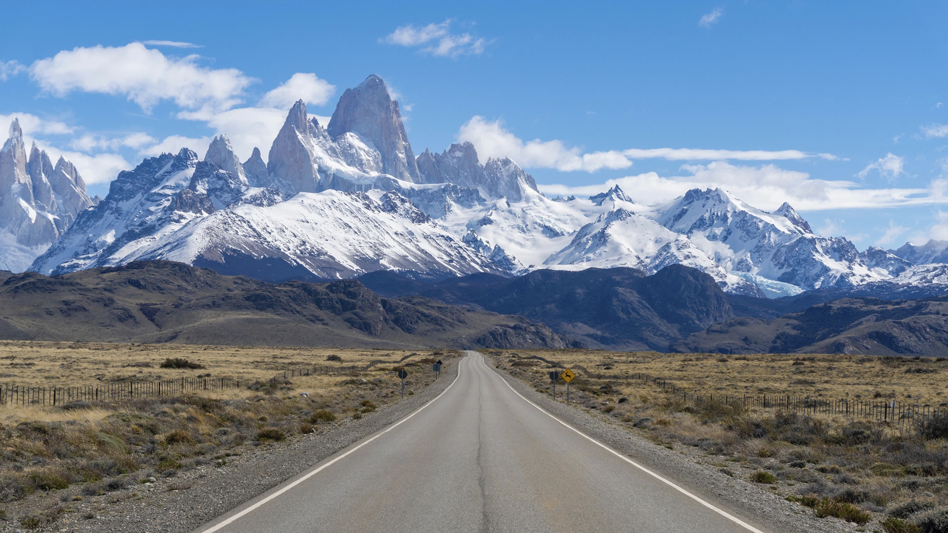
Leaving Gobernador Gregores behind, the road stretches straight and empty for miles — until, like a mirage, the jagged skyline of the Fitz Roy Massif rises ahead. This detour to El Chaltén, Patagonia’s trekking capital, is not only visually breathtaking, but spiritually energizing. Even if you’re not hiking, simply standing beneath those granite towers is unforgettable. The small town of El Chaltén has a welcoming atmosphere, great food, and epic viewpoints just a short walk or ride away.
Highlights:
- Stunning approach to Fitz Roy on Ruta 23
- Sunset views from Mirador de los Cóndores
- Easy hike or ride to Laguna Capri or Chorrillo del Salto
- Cozy hostels and mountain vibes in El Chaltén
Notes:
- Strong winds common on Ruta 40 — hold steady, especially near La Leona
- Fuel up in Tres Lagos; next pump in El Chaltén
- Book accommodation in advance in high season (January–February)
Option: Gobernador Gregores → El Calafate (direct)
The fastest way to the ice fields
Distance: ~350 km
Time: 5.5–6 hours
Road: Mostly paved (Ruta 40), one ~70 km gravel section near Tres Lagos
This more direct route skips the Chaltén detour and leads you straight to El Calafate, gateway to the legendary Perito Moreno Glacier. While the scenery is more subdued compared to the El Chaltén leg, it’s a smooth ride through open steppe, with views of turquoise glacial lakes along the way. El Calafate itself is a bustling town with excellent restaurants, hotels, and tour options — the perfect place for a well-earned break.
Highlights:
- Efficient link to southern Patagonia
- Lago Argentino and early glimpses of the Southern Icefield
- Plenty of lodging, food, and fuel in El Calafate
Tipp:
If time allows, consider staying one night in El Chaltén, then continuing to El Calafate the next day (~220 km / 3.5 hours). This way, you won’t miss Patagonia’s most iconic peaks.
Day 12: El Calafate – A Detour to Los Glaciares National Park
Witness the Power of Ice
After days of riding through wind-swept steppes and glacier-fed lakes, it’s time to slow down and absorb one of Patagonia’s most surreal wonders: the Perito Moreno Glacier. From El Calafate, a scenic 80 km paved ride leads into Parque Nacional Los Glaciares, a UNESCO World Heritage Site and home to one of the world’s most active and accessible ice fields. The road winds along the shores of Lago Argentino, flanked by lenga forests and distant mountain silhouettes, until — without warning — a massive wall of ice appears before you.
Highlights:
- The Perito Moreno Glacier: 30 km long, 5 km wide, and still advancing — one of the few glaciers on Earth that is not retreating
- Balconies and walkways offer spectacular panoramic views and thunderous ice calving moments
- Optional boat trips get you close to the 70-meter-high ice face
- Photography at sunrise or sunset can be magical
Rider Tips:
- Best visited in the morning before tourist crowds arrive
- Parking for motorcycles is easy and close to the trailheads
- Pack a windbreaker — even on sunny days, glacier breezes are icy
- Fuel up in El Calafate before heading out and back (~160 km round trip)
Optional Add-On:
Feeling adventurous? Book a guided mini-trek on the glacier itself (crampons included) for a once-in-a-lifetime ice hike — no previous experience needed.
Note:
This detour is not just a scenic side trip — it’s a Patagonian pilgrimage. Riders often cite it as one of the emotional high points of their journey. Few places on Earth make you feel as small, and as in awe, as this cathedral of ice.
Day 13: El Calafate → Puerto Natales
Gateway to Torres del Paine
Leaving El Calafate, the route crosses wide open pampas and leads to the Chilean border at Paso Río Don Guillermo or Paso Casas Viejas (depending on road and weather conditions). After border formalities, the road gradually descends into southern Chile’s rugged landscapes — forests, fjords, and jagged granite peaks begin to appear as you approach Puerto Natales, a charming port town on the shores of Seno Última Esperanza (Last Hope Sound).
Puerto Natales is more than just a stopover — it’s the launchpad for Torres del Paine, Chile’s most iconic national park and one of South America’s natural crown jewels.
Rider Notes:
- Roads are paved all the way, but watch for strong side winds between La Esperanza and the border
- Border crossing can take time — carry your documents and remain patient
- Fuel is available in El Calafate, Esperanza (limited), and Puerto Natales
- Expect dramatic weather changes throughout the day
Option: Torres del Paine National Park – Day Excursion
Where Nature Roars
A full-day ride or guided tour from Puerto Natales takes you into the heart of Parque Nacional Torres del Paine. This legendary park combines glacial lakes, raging rivers, grazing guanacos, and the towering granite torres (towers) that give the park its name.
Highlights:
- Lago Grey and the Grey Glacier
- The famous Cuernos del Paine rock formations
- Salto Grande, a thunderous waterfall between glacial lakes
- Herds of guanacos, foxes, condors — and if lucky, a puma sighting
- Endless hiking or photo opportunities along scenic roads
Motorcycle Tips:
- Most access roads inside the park are gravel, but usually well-graded
- Dual-sport or adventure motorcycles are ideal — be cautious after rain
- Entry requires a fee — online pre-registration is recommended
- Carry snacks, layers, and full fuel — services inside the park are minimal
Recommended Stay:
Spend at least 2 nights in Puerto Natales to allow for a full day in the park. From stylish eco-lodges to cozy hostels, the town caters to all travel styles.
Pro Tip:
If you’re tight on time or riding two-up, consider a day tour by van or boat — it’s an efficient and relaxing way to see the park’s main sights without battling the wind on gravel. In addition, during peak season, roads in the national park can be heavily congested with tourist traffic and dusty, which can make motorcycling unpleasant. On the Get Your Guide platform you will find many great tour offers. The boat trip on Grey Lake is very popular.
Day 14: Puerto Natales → Cerro Sombrero
Across the Pampas to Tierra del Fuego
From Puerto Natales, the journey heads east and then south across the vast Patagonian steppe — wide skies, endless horizons, and the constant presence of wind accompany you. The paved Road leads through Villa Tehuelches and then Punta Delgada, where you’ll board a short ferry to Tierra del Fuego — the legendary island at the end of the world.
After crossing the Strait of Magellan, you reach Cerro Sombrero, a quiet oil town and the first proper settlement on the Chilean side of the island. While not touristy, it’s the perfect overnight stop with fuel, simple accommodation, and a sense that you’re now truly far away from it all.
Route Details:
- Distance: ~420 km
- Road: Fully paved until the ferry; short gravel stretch after the ferry (~15–30 km, depending on roadworks)
- Ferry crossing at Bahía Azul (Primera Angostura): ~20 min, frequent departures during daylight hours
- No reservation needed, but small queues are possible during high season
Highlights:
- Ride across the desolate and beautiful pampas of southern Chile
- Cross the historic Magellan Strait — a milestone for any rider
- First night on Tierra del Fuego, land of stories, solitude, and striking light
- Wildlife: Keep an eye out for ñandúes, guanacos, and even flamingos in roadside lagoons
Rider Tips:
- Fill up in Puerto Natales and again in Villa Punta Delgada if needed
- Strong side winds are very common in this area — ride defensively
- The ferry operates year-round, but check wind conditions if traveling late in the day
- Warm layers are essential — even in summer, the temperature drops quickly with the wind
Accommodation Tip:
Cerro Sombrero has a cozy hotel and basic guesthouses, often frequented by overlanders and riders. It’s not fancy — but it’s safe, warm, and filled with stories.
Day 15: Cerro Sombrero → Ushuaia (ca. 440 km)
The End of the World
This is it — the final and most symbolic leg of your Patagonian motorcycle journey: crossing Tierra del Fuego to reach Ushuaia, the southernmost city in the world.
From Cerro Sombrero, the route heads east toward the border at San Sebastián (Chile to Argentina). Once formalities are done, you ride south on Ruta 3, leaving the windswept steppe behind as the Andes reappear in dramatic fashion. The landscape shifts quickly — forests, lakes, and snowcapped peaks replace the open plains. After passing Tolhuin and the shores of Lago Fagnano, the final stretch winds through the Paso Garibaldi, with breathtaking views down to the Beagle Channel and Ushuaia nestled on its shore.
You made it.
Route Details:
- Distance: ~440 km
- Road: Fully paved
- Border crossing: San Sebastián (Chile–Argentina) — usually smooth, but allow extra time
- Fuel: Available in Cerro Sombrero, Rio Grande, Tolhuin, and Ushuaia
Highlights:
- Crossing into Argentinian Tierra del Fuego, a vast and lonely landscape
- Stop at Lago Fagnano for a scenic break
- Twisties through the Fuegian Andes — a beautiful reward after the long straight roads
- Your first glimpse of the Beagle Channel from the Garibaldi Pass
- Arrival in Ushuaia, the end (or beginning) of the world
Rider Notes:
- Winds can be very strong until Tolhuin — stay alert, especially when overtaking trucks
- Watch for black ice or fog in Paso Garibaldi, especially in the morning
- Entering Ushuaia feels like a victory — take your time, and take it in
Optional Activities in Ushuaia:
- Visit Parque Nacional Tierra del Fuego
- Ride to Bahía Lapataia, the official end of Ruta 3
- Book a boat tour on the Beagle Channel (penguins, sea lions, lighthouse)
- Enjoy local seafood and craft beer — you earned it
Option: Rest Day in Ushuaia
Take a Breath at the End of the World
After thousands of kilometers through towering mountains, endless steppe, and some of the wildest landscapes on earth, Ushuaia invites you to slow down and take it all in. This is no ordinary rest day — it’s a moment of arrival. Nestled between the Martial Mountains and the Beagle Channel, the southernmost city in the world offers a mix of rugged beauty, culture, and calm. Take time to reflect, celebrate, and discover.
What to Do:
Explore the Town
Stroll through the harbor and along the waterfront promenade. Visit the Museo del Fin del Mundo to learn about the region’s indigenous peoples and explorers.
Beagle Channel Boat Tour
Cruise the legendary channel past Les Éclaireurs Lighthouse, penguin colonies (seasonal), sea lions, and dramatic landscapes. A truly unforgettable experience.
Tierra del Fuego National Park
Just 12 km from town, you can hike in pristine nature — forests, lakes, and the official end of Ruta Nacional 3 at Bahía Lapataia. Half-day and full-day hikes available.
Souvenirs & Café Culture
Ushuaia has cozy cafés, chocolaterías, and plenty of shops for last-minute gifts: mate sets, hand-knitted wool, and everything “Fin del Mundo.”
Practical Notes:
- Fuel, ATMs, and supermarkets are easily available
- Motorcycle servicing available upon request
- Great place to ship gear or repack for the return trip
- Many riders take an extra day here — and never regret it
Optional Add-On:
If you’re craving one extra ride, take the short but stunning road to Estancia Harberton or along Ruta J for remote views over the Channel.
The Last Kilometer – Ride to Bahía Lapataia
This short but symbolic ride leads you to the very end of Ruta Nacional 3, the southernmost road of the Americas. From the center of Ushuaia, head west into Tierra del Fuego National Park — a place of pristine forests, glacier-fed lakes, and wildlife. The road winds through lenga forests, past quiet rivers and beaver dams, until it quite literally ends at Bahía Lapataia. Here, you’ll find a wooden sign beloved by overlanders and motorcyclists alike — declaring your arrival at the end of the Pan-American Highway:
“Here ends Ruta Nacional Nº 3. Buenos Aires 3.079 km – Alaska 17.848 km” Take a moment to savor it. This is a place that carries meaning far beyond its remote location.
Highlights:
- Short, scenic ride (about 25 km one way) from Ushuaia
- Views of Lago Roca (Acigami) and the Lapataia River
- Wildlife sightings: foxes, black-necked swans, condors
- The “last post station” — a small wooden hut with a unique stamp for your passport
- Optional short hikes into the lenga forest or along the bay
Rider Notes:
- Entrance to the park requires a small fee (bring cash)
- Motorcycles are allowed on all main roads inside the park
- The final kilometer to the Lapataia sign is a gravel road, well maintained but can be muddy after rain
- Ideal time: early morning or late afternoon for light and fewer visitors
A Ride to Remember
More than a destination, Bahía Lapataia is a symbol: of persistence, exploration, and the wide open road. This is your final kilometer — and a story you’ll tell forever.
Day 16: Ushuaia → Río Grande
Wind, Valleys & Empty Roads – Back Across the Island
Distance: ~210 km · Road surface: Fully paved · Riding time: approx. 3–4 hours
After reaching the symbolic end of the road at Bahía Lapataia, it’s time to turn north and begin the long journey home — but Patagonia isn’t finished with you yet. Leaving Ushuaia behind, you’ll retrace the scenic Ruta Nacional 3 over the Garibaldi Pass, climbing once more through the Fuegian Andes, where twisted forests and misty peaks guard the way. The descent opens onto a new landscape — vast open valleys, windswept plains, and skies that stretch forever.
As you ride through Tolhuin, the halfway point, don’t miss a stop at the famous Panadería La Unión — a quirky, beloved bakery where travelers, truckers and locals mingle over empanadas and fresh bread.
The final stretch to Río Grande leads you through wide steppe landscapes and past wind farms — and, most likely, into strong Patagonian winds. Keep a firm grip on the bars!
Highlights:
- Garibaldi Pass: Great views from the summit and excellent curves on both sides
- Lago Fagnano (Khami): Optional short detour for a photo stop at the lake shore
- Panadería La Unión: A true institution in Tolhuin — fuel up with coffee and snacks
- Patagonian Steppe Light: As the land flattens out, the golden hues and long shadows are unforgettable
Rider Notes:
- Expect strong side winds especially north of Tolhuin
- Gas stations in Tolhuin and Río Grande – fill up before leaving Ushuaia
- Watch for guanacos and occasional sheep on the road
- In cooler months, black ice is possible in shaded area
Río Grande may not be glamorous, but it’s a key waypoint for all riders traversing Tierra del Fuego — and a great place to rest, refuel, and prepare for the ferry crossing ahead.
Touching the Atlantic – Río Grande’s Windy Shoreline
Río Grande may be known as an industrial and fishing town, but for travelers who’ve crossed the Andes, the steppe, and the forests of Tierra del Fuego, standing on the shore of the South Atlantic is a deeply meaningful moment.
Just a few minutes from the town center, the wide pebble beach opens up to the icy blue waters of the Atlantic Ocean. The coastline stretches endlessly, framed by dunes, low cliffs, and the ever-present southern wind. It’s a great place to reflect on how far you’ve come — from the Pacific to the Atlantic, from the Andes to the edge of the world.
On a calm evening (rare, but magical), the beach glows in golden light and seabirds hover above the waves. This isn’t a swimming beach — the waters are cold and rough — but it’s a place of vastness, solitude, and striking beauty.
Day 17: Río Grande → Punta Arenas
Crossing the Strait – Two Routes to the Gateway of Patagonia
- Option 1 (via Porvenir ferry): ~240 km
- Option 2 (via Punta Delgada): ~470 km
Ride time: 5–8 hours (depending on route & ferry schedule)
Road surface: Mostly paved, some gravel sections
Your last day on Tierra del Fuego begins with one of the most remote and elemental rides of the journey — across open steppe, windswept plains, and eventually the legendary Strait of Magellan.
Option 1: The Scenic Route via Porvenir Ferry
From Río Grande, ride south toward Cameron and then on to Porvenir, the largest settlement on the Chilean side of Tierra del Fuego. The road is remote, often unpaved, and exposed to wind — but the scenery is stark and beautiful, with grazing guanacos and sweeping views.
The ferry from Porvenir to Punta Arenas takes about 2.5 hours, crossing the strait where Darwin once sailed. It’s a magical and historic passage — but the ferry is often canceled due to strong winds. Always check the schedule and wind conditions in advance.
If you’re feeling adventurous and the timing works, this route is unforgettable.
Tip: Check the official TABSA ferry website (www.tabsa.cl) or ask your hotel about current sailing conditions. Wind can be brutal — flexibility is key.
Option 2: The Reliable Route via Punta Delgada
If the Porvenir ferry is not operating (or you prefer a smoother ride), you’ll continue north along RN3 to the border crossing at San Sebastián, and then into Chile.
From there, head west to Punta Delgada, where a short ferry (20 minutes) takes you across the Strait. These ferries run frequently and are rarely canceled.
From the mainland side, it’s a straight and easy ride south to Punta Arenas.
Highlights en route:
- Vast open Patagonian steppe and wildlife (especially guanacos and ñandú)
- The historic Strait of Magellan, one of the world’s great natural crossings
- Optional stop at Estancia San Gregorio – a ghostly abandoned sheep station with shipwrecks on shore
- Arrival in Punta Arenas, the southern capital of Chilean Patagonia, full of history and hospitality
Rider Notes:
- Always check ferry schedules and wind conditions the night before
- Fuel up in Río Grande — fuel stops are sparse in Tierra del Fuego
- Winds north of Río Grande and across the strait can be very strong
- Border crossing (Argentina ↔ Chile): San Sebastián or Bella Vista (Porvenir route) – bring your vehicle papers and patience
Punta Arenas marks the end of your motorcycle journey — a rugged, windswept city on the edge of the continent, where the motorcycles will be picked up for return transport. Time to enjoy a hot meal, a warm bed, and perhaps a glass of Chilean wine to toast the ride of a lifetime.